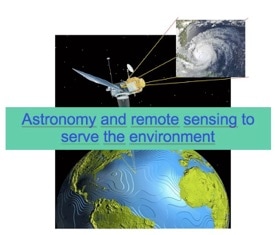
Remote sensing
|
Remote sensing means measuring an object at a distance without physical contact with it. In this section of podcast, fundamentals such as spectral signatures, real and false color image, ... are introduced.
These exercises are specifically targeted for K12 level student, just to introduce the Remote Sensing concepts, and some practical exercise with “Leoworks” a free software from ESA |
|
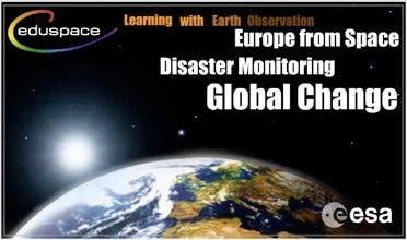
The European Earth Observation Web Site for Secondary Schools
www.esa.int/SPECIALS/Eduspace_EN/SEMNNBANJTF_0.html |
|
LEOWorks is a didactical tool with extensive help pages and an all-inclusive tutorial (see right of page). With the assistance of this documentation, students will be able to experiment with their own imagery and undertake their own processing. LEOWorks is compatible with data collected by several Earth Observation missions, and can read most standard image formats (e.g. jpg, tif, bmp, png).
LEOWorks 4 is the latest version of the software and it is platform independent (Windows, MacOS, Linux). |
|
Earth Observation in the classroom
from the Belgian Federal Science Policy Office. This website introduces remote sensing and the processes of satellite data acquisition, image processing and analysis. only available in French and Dutch eoedu.belspo.be/ |
|
PW0: Introduction to satellite image.
A PowerPoint presentation to introduce the concept of satellite image. Also a document for the student and for the teacher. How we can build a image (without the leoworks soft) 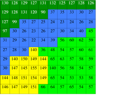
| ||||||
|
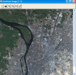
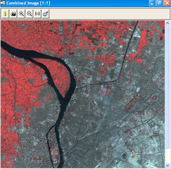
PW 1 : Images in true and false colors of the town of Cairo as it is seen by the Landsat satellite (LEOWORKS)
Objective :
| ||
|
|
|
PW2: Spectral responses starting from true or false color images (LEOWORKS)
Objectives :
| ||
|
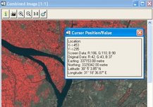
PW 3: Measuring distances on an image (LEOWORKS)
Objectives :
| ||
|
Presentation and suggestions for pedagogical exploitation of the CD-ROM : « Guyana seen through the clouds » (ESA)
Proposals for pedagogical exploitation It can be interesting for students to discover the CD-ROM by themselves. But the teacher should first explain briefly how to use it, how to ‘travel’ through the CD-ROM. Using a questionnaire might prove the best way for students to discover the CD-ROM (see below). Students can go through the first questionnaire in groups of two or three. That work can first be marked and then corrected in class. The second questionnaire is meant to be answered individually, as a final test. The presentation of the CD-ROM by the teacher and going through the CD-ROM by means of the first questionnaire in work groups should take two periods of 50 minutes. | ||||
|
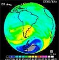
Exercises about ozone
Objective −Learn about the ozone layer and its variations −Learn about measurements of the ozone layer −Use of excel-software −Graphic presentation of data −Analysis of data −Give an evaluation of different graphic presentations - be critical −Develop own ideas for further analysis of the available data −Use statistics −Encourage to find recent data on the internet −Encourage the students to ask questions and to try to find answers Subjects that can be involved: Physics: Satellite measurements, absorption of radiation Geography: Ozone layer . Projections Biology: Risk of high UV concentrations Information technology: –use of a calculation program (Microsoft Excel) to make calculations and draw graphs –make an animation of a series of pictures (e.g. a GIF-animation by using freeware from the Internet) Mathematics: Statistics | ||||||||||||||||
|
PHYSICS OF RADIATION IN REMOTE SENSING
There is no Remote sensing without physics. Pupils should learn

| ||||
|
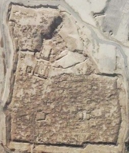
Practical work about Earthquake: Devastation and Recovery Bam, Iran
Level : These lessons are meant for forth-year students (14-15 year old students / secondary education - general) Skill to be practiced: The students must be able to “look for the causes and the consequences of phenomena they have studied, as well as their interactions.” Necessary background : It may be useful to explain what a satellite picture is. There is however no necessary background since the vocabulary that will be used can be explained during exercises proposed by the teacher. This sequence can either be an introduction to the issue of plate tectonics, or some exercises about that theory. It can also be integrated in lessons on natural catastrophes. | ||||||||||